Tugaske (crater)
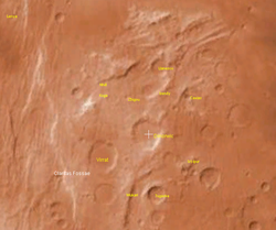
Tugaske is a Martian impact crater, approximately 31 kilometres in diameter. It is located at 32.1°S, 101.2°W, south of the crater Dinorwic and southeast of the crater Virrat . It is named after a town in Saskatchewan , Canada , and its name was approved by the International Astronomical Union in 1991. [1] [2] According to a surface age map of Mars based on US Geological Survey data, the area around Tugaske is from the Noachian epoch , which places the area's age at 3.8 to 3.5 billion years ago. [3] The elevation around the rim averages about 6700 meters above zero altitude, and the deepest part of the crater floor, in the central pit, measures 5,100 meters above zero altitude. The crater is therefore about 1.6 kilometers deep. [2]
Page Revisions
| Year | Metadata | Sections | Top Words | First Paragraph |
| 2018 |
74266 characters 1 sections 2 paragraphs 3 images 654 internal links 3 external links |
tugaske 0.520 6700 0.308 saskatchewan 0.248 virrat 0.248 dinorwic 0.218 altitude 0.181 age 0.174 averages 0.166 101 0.163 deepest 0.159 crater 0.155 epoch 0.142 pit 0.136 meters 0.136 1991 0.130 |
Tugaske is a Martian impact crater, approximately 31 kilometres in diameter. It is located at 32.1°S, 101.2°W, south of the crater Dinorwic and southeast of the crater Virrat . It is named after a town in Saskatchewan , Canada , and its name was approved by the International Astronomical Union in 1991. [1] [2] According to a surface age map of Mars based on US Geological Survey data, the area around Tugaske is from the Noachian epoch , which places the area's age at 3.8 to 3.5 billion years ago. [3] The elevation around the rim averages about 6700 meters above zero altitude, and the deepest part of the crater floor, in the central pit, measures 5,100 meters above zero altitude. The crater is therefore about 1.6 kilometers deep. [2] |
|
| 2017 |
32883 characters 1 sections 2 paragraphs 6 images 161 internal links 3 external links |
tugaske 0.520 6700 0.308 saskatchewan 0.248 virrat 0.248 dinorwic 0.218 altitude 0.181 age 0.174 averages 0.166 101 0.163 deepest 0.159 crater 0.155 epoch 0.142 pit 0.136 meters 0.136 1991 0.130 |
Tugaske is a Martian impact crater, approximately 31 kilometres in diameter. It is located at 32.1°S, 101.2°W, south of the crater Dinorwic and southeast of the crater Virrat . It is named after a town in Saskatchewan , Canada , and its name was approved by the International Astronomical Union in 1991. [1] [2] According to a surface age map of Mars based on US Geological Survey data, the area around Tugaske is from the Noachian epoch , which places the area's age at 3.8 to 3.5 billion years ago. [3] The elevation around the rim averages about 6700 meters above zero altitude, and the deepest part of the crater floor, in the central pit, measures 5,100 meters above zero altitude. The crater is therefore about 1.6 kilometers deep. [2] |
|
| 2015 |
31226 characters 1 sections 2 paragraphs 6 images 160 internal links 2 external links |
tugaske 0.520 6700 0.308 saskatchewan 0.248 virrat 0.248 dinorwic 0.218 altitude 0.181 age 0.174 averages 0.166 101 0.163 deepest 0.159 crater 0.155 epoch 0.142 pit 0.136 meters 0.136 1991 0.130 |
Tugaske is a Martian impact crater, approximately 31 kilometres in diameter. It is located at 32.1°S, 101.2°W, south of the crater Dinorwic and southeast of the crater Virrat . It is named after a town in Saskatchewan , Canada , and its name was approved by the International Astronomical Union in 1991. [1] [2] According to a surface age map of Mars based on US Geological Survey data, the area around Tugaske is from the Noachian epoch , which places the area's age at 3.8 to 3.5 billion years ago. [3] The elevation around the rim averages about 6700 meters above zero altitude, and the deepest part of the crater floor, in the central pit, measures 5,100 meters above zero altitude. The crater is therefore about 1.6 kilometers deep. [2] |
|
| 2013 |
31148 characters 1 sections 1 paragraphs 6 images 160 internal links 2 external links |
tugaske 0.520 6700 0.308 saskatchewan 0.248 virrat 0.248 dinorwic 0.218 altitude 0.181 age 0.174 averages 0.166 101 0.163 deepest 0.159 crater 0.155 epoch 0.142 pit 0.136 meters 0.136 1991 0.130 |
Tugaske is a Martian impact crater, approximately 31 kilometres in diameter. It is located at 32.1°S, 101.2°W, south of the crater Dinorwic and southeast of the crater Virrat . It is named after a town in Saskatchewan , Canada , and its name was approved by the International Astronomical Union in 1991. [1] [2] According to a surface age map of Mars based on US Geological Survey data, the area around Tugaske is from the Noachian epoch , which places the area's age at 3.8 to 3.5 billion years ago. [3] The elevation around the rim averages about 6700 meters above zero altitude, and the deepest part of the crater floor, in the central pit, measures 5,100 meters above zero altitude. The crater is therefore about 1.6 kilometers deep. [2] |
|
| 2012 |
9810 characters 1 sections 2 paragraphs 2 images 16 internal links 2 external links |
tugaske 0.520 6700 0.308 saskatchewan 0.248 virrat 0.248 dinorwic 0.218 altitude 0.181 age 0.174 averages 0.166 101 0.163 deepest 0.159 crater 0.155 epoch 0.142 pit 0.136 meters 0.136 1991 0.130 |
Tugaske is a Martian impact crater, approximately 31 kilometres in diameter. It is located at 32.1°S, 101.2°W, south of the crater Dinorwic and southeast of the crater Virrat . It is named after a town in Saskatchewan , Canada , and its name was approved by the International Astronomical Union in 1991. [1] [2] According to a surface age map of Mars based on US Geological Survey data, the area around Tugaske is from the Noachian epoch , which places the area's age at 3.8 to 3.5 billion years ago. [3] The elevation around the rim averages about 6700 meters above zero altitude, and the deepest part of the crater floor, in the central pit, measures 5,100 meters above zero altitude. The crater is therefore about 1.6 kilometers deep. [2] |
|
| 2011 |
9802 characters 1 sections 2 paragraphs 2 images 16 internal links 2 external links |
tugaske 0.520 6700 0.308 saskatchewan 0.248 virrat 0.248 dinorwic 0.218 altitude 0.181 age 0.174 averages 0.166 101 0.163 deepest 0.159 crater 0.155 epoch 0.142 pit 0.136 meters 0.136 1991 0.130 |
Tugaske is a Martian impact crater, approximately 31 kilometres in diameter. It is located at 32.1°S, 101.2°W, south of the crater Dinorwic and southeast of the crater Virrat . It is named after a town in Saskatchewan , Canada , and its name was approved by the International Astronomical Union in 1991. [1] [2] According to a surface age map of Mars based on US Geological Survey data, the area around Tugaske is from the Noachian epoch , which places the area's age at 3.8 to 3.5 billion years ago. [3] The elevation around the rim averages about 6700 meters above zero altitude, and the deepest part of the crater floor, in the central pit, measures 5,100 meters above zero altitude. The crater is therefore about 1.6 kilometers deep. [2] |
|
| 2009 |
9802 characters 1 sections 2 paragraphs 2 images 16 internal links 2 external links |
tugaske 0.520 6700 0.307 saskatchewan 0.247 virrat 0.247 dinorwic 0.217 altitude 0.181 age 0.174 averages 0.166 101 0.163 deepest 0.159 crater 0.155 epoch 0.142 pit 0.136 meters 0.135 1991 0.130 |
Tugaske is a Martian impact crater, approximately 31 kilometers in diameter. It is located at 32.1°S, 101.2°W, south of the crater Dinorwic and southeast of the crater Virrat . It is named after a town in Saskatchewan , Canada , and its name was approved by the International Astronomical Union in 1991. [1] [2] According to a surface age map of Mars based on US Geological Survey data, the area around Tugaske is from the Noachian epoch , which places the area's age at 3.8 to 3.5 billion years ago. [3] The elevation around the rim averages about 6700 meters above zero altitude, and the deepest part of the crater floor, in the central pit, measures 5,100 meters above zero altitude. The crater is therefore about 1.6 kilometers deep. [2] |
|
| 2008 |
10718 characters 1 sections 1 paragraphs 2 images 17 internal links 2 external links |
tugaske 0.520 6700 0.307 saskatchewan 0.247 virrat 0.247 dinorwic 0.217 altitude 0.181 age 0.174 averages 0.166 101 0.163 deepest 0.159 crater 0.155 epoch 0.142 pit 0.136 meters 0.135 1991 0.130 |
Tugaske is a Martian impact crater, approximately 31 kilometers in diameter. It is located at 32.1°S, 101.2°W, south of the crater Dinorwic and southeast of the crater Virrat . It is named after a town in Saskatchewan , Canada , and its name was approved by the International Astronomical Union in 1991. [1] [2] According to a surface age map of Mars based on US Geological Survey data, the area around Tugaske is from the Noachian epoch , which places the area's age at 3.8 to 3.5 billion years ago. [3] The elevation around the rim averages about 6700 meters above zero altitude, and the deepest part of the crater floor, in the central pit, measures 5,100 meters above zero altitude. The crater is therefore about 1.6 kilometers deep. [2] |
|
| 2007 |
10756 characters 1 sections 1 paragraphs 2 images 18 internal links 2 external links |
tugaske 0.520 6700 0.307 saskatchewan 0.247 virrat 0.247 dinorwic 0.217 altitude 0.181 age 0.174 averages 0.166 101 0.163 deepest 0.159 crater 0.155 epoch 0.142 pit 0.136 meters 0.135 1991 0.130 |
Tugaske is a Martian impact crater, approximately 31 kilometers in diameter. It is located at 32.1°S, 101.2°W, south of the crater Dinorwic and southeast of the crater Virrat . It is named after a town in Saskatchewan , Canada , and its name was approved by the International Astronomical Union in 1991 . [1] [2] According to a surface age map of Mars based on US Geological Survey data, the area around Tugaske is from the Noachian epoch , which places the area's age at 3.8 to 3.5 billion years ago. [3] The elevation around the rim averages about 6700 meters above zero altitude, and the deepest part of the crater floor, in the central pit, measures 5,100 meters above zero altitude. The crater is therefore about 1.6 kilometers deep. [2] |